Where the Heck Is Hell's Kitchen?
New York is a city of neighborhoods — but where those neighborhoods begin and end isn't entirely clear.
The city has a map that's designed for use with census data, but it mushes together neighborhoods like Chelsea, the Flatiron District and Union Square, while splitting others like Crown Heights apart.
WNYC has used those zones to map median incomes and pre-K seats in the past, but we still don't have a good definition of individual neighborhoods.
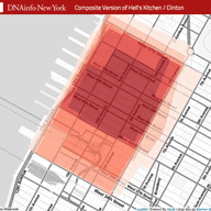
To find out how residents themselves defined their neighborhoods, DNAinfo asked their readers to crowdsource the boundaries. More than 12,000 people participated, and the results are in.
Nigel Chiwaya, a visual journalist at DNAinfo, says there were several interesting disagreements, such as where to draw the eastern edge of Chelsea (7th Avenue or 6th Avenue?), the boundary between Washington Heights and Inwood (who gets Broadway south of Dyckman Street?) and the southern edge of Hell's Kitchen.
"Newer residents tended to stop Hell's Kitchen at around 42nd Street, whereas older residents tended to keep it going all the way down to 34th Street," he said.
The L.A. Times has done something similar there, and in San Francisco there's an effort to detect neighborhood boundaries by where people say they live in Craigslist postings. There's also an analysis of Foursquare data that tries to find the lines based on where people hang out.
Update, Oct. 7: Folks on Twitter have pointed out other efforts to map neighborhoods in Boston, Seattle, Vancouver, Portland, Minneapolis, St. Paul and Chicago:
@jkeefe Good writeup. Also, Boston http://t.co/jx5bMlv7bD Pacific NW http://t.co/FVXy9MVfR1 Minneapolis http://t.co/EjourHFWh3 & more?
— Steven Romalewski (@SR_spatial) October 6, 2015
@sr_spatial @jkeefe We also helped put together one for @DNAinfoCHI with @tanveerali here: http://t.co/MIUqY2pj5y
— NiJeL (@nijel_mapping) October 6, 2015

WNYC is funded by sponsors and member donations